Friday, February 21, 2014

Sun, Sand and Surf at the Last Stop on Our Around The World Journey: Two Weeks in Southeastern Australia

Squeaky Beach at Wilson's Promotory
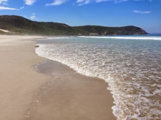
One of southeastern Australia's many beaches,
Squeaky Beach at Wilson's Promotory

We're half-way through our whirlwind two-week tour of Australia. I know, I know, two weeks is not enough time to devote to such a large and diverse country but at this point in the game - eight months into our around the world journey - two weeks is all we can manage to eke out of the remains of our travel budget. And I do mean, 'eke'. Yes, there's lots of brown rice with tuna and chopped tomato on the menu these days...

But back to the more important details at hand! The vast multitude of gorgeous beaches in this limited corner of the globe have made us realize there's an obvious lack of lovely, swimmable ocean beaches in Canada. How lucky the Australians are! Every inch of this coast seems to be blessed with soft, powdery sand, good surf and an endless parade of holiday parks to ensure travelers will find all the comforts of home just a short walk across the road.

We've been here for less than a week and have been making our way along the coast from Melbourne to Brisbane. At the moment, we're in picturesque Mallacoota, just south of the Victoria/New South Wales boarder. Our travel brochures tell us that, as straight as the crow flies, we're only about 500km from Melbourne, but the odometer on our rental vehicle tells us we've actually traveled about 700km to arrive here.

Similar to other places we've stopped at along the way, we're lazing away our days soaking up the sun on the area's many beaches and hiking the trails in the nearby national park. On this stop, the nearby park is the very impressive Croajingolong National Park which, along with the adjoining Nadgee Nature Reserve, is classified as one of only 12 World Biosphere Reserves in Australia. Considering it's unique designation, it's no surprise that Croajingolong possesses some of the most photogenic beaches we've seen in a year's worth of travels. To add to the fun, we're staying in a great campsite located on a lovely stretch of the area's 320km of coastline. Needless to say, we're having a fine time in good ol' Mallacoota!

Beach in Mallacoota
We often have the beach all to ourselves at
the campsite in Mallacoota

One of the many beautiful views along the Mallacoota Coastal Walk

Other favourite spots on our Australian journey so far were Rosebud on the Mornington Peninsula, where we enjoyed the views at nearby Point Nepean National Park, and Cape Conran, which appeared to be a popular spot for young surfers to hone their skills.

Cape Conran Coastal Park

The true highlight of our trip so far though has been our visit to Wilson's Promotory, also known as 'The Prom'. We loved the stunning coastal views, great variety of trails and the well serviced campsite located right beside the oceanfront beach!

View from the summit of Mount Oberon, Wilson's Promotory
View from the summit of Mount Oberon,
Wilson's Promotory

Footprints in the sand on Squeaky Beach
Squeaky Beach is covered with rounded quartz sand that actually
squeaks as you walk on it!

It's a little sad to think that in just a few short weeks, our "journey of a lifetime" will come to an end. Yes, as the saying goes (and my bank account heartily agrees), all good things must come to an end. If it must end, I couldn't think of a better way to do it than savouring a laid-back road trip in a land far, far away in the southern hemisphere. Our trip may be winding down, but we've still got a lot of miles to travel before we reach home and with the majority of the wild chaos of the past eight months behind us, there seems to be plenty of time to think and reflect…and maybe even start planning for our next "journey of a lifetime".

Thursday, February 06, 2014

There and Back Again: 40km on the Routeburn Track

Baasje and I at the summit of Conical Hill
The summit of Conical Hill. We made it!

Day 1: Routeburn Shelter to Routeburn Flats Campsite, 6.5km

Dinner: Pasta with chorizo and tomato sauce

There's heavy debate in the backpackers and holiday parks we've been staying at in Fiordland over which is the better track, the Routeburn or the Kepler. We've heard very convincing arguments on both sides, but the verdict seems to be a bit in favour of the Routeburn and on day one of our hike it was already easy to see why. We were especially impressed by the amazing blue-hued water in the stream running alongside the trail and the picture-perfect alpine setting at the Routeburn Flats campsite. But the best was yet to come!

Stream
Turquoise water!

Our tent pitched at Routeburn Flats campsite
Campsite at Routeburn Flats

Day 2: Routeburn Flats Campsite, to Lake McKenzie Campsite, 13.4km + Summit of Conical Hill

Breakfast: Oatmeal, crackers, cheese, peanut butter

Lunch: Cheese and chorizo sandwiches
 

Snack: Cous cous and chicken

Dinner: Mashed potatoes and savoury mince


We have a winner! The view from Conical Hill takes the cake for our favourite alpine view of our around-the-world journey (taking over from the previous reigning champion, Sentinel Pass in Banff National Park, followed closely by the views at O'Cebreiro in Spain). The stunning alpine vista was definitely worth the long climb up from Routeburn Flats which, in case you're wondering, took us about 4 hours with a snack break at the Harris Saddle shelter. We were so impressed by the view, we found it hard to tear ourselves away to continue with the rest of the day's hike--it was that spectacular! In fact, once we climbed away from the tree line and past the Routeburn Falls Hut, we were pretty much gobsmacked by the views all the way to Lake McKenzie.

View of the trail over Lake Harris
The climb above Lake Harris

Looking down on the Harris Saddle shelter from Conical Hill

Baasje at the Lake Harris viewpoint
Lake Harris viewpoint on Conical Hill

View from the summit of Conical Hill

As we headed across the Hollyford Valley face I came to suspect that some might prefer the Kepler Track for its long chain of ridge walks which offer 360 degree views down into the valleys below, but I'd take the Routeburn over the Kepler any day!

Alpine pond near the Harris Saddle shelter

Baasje looking out over the Hollyford Valley
Admiring the view of the Hollyford Valley

The trail from Harris Saddle shelter to Lake McKenzie

Baasje on the trail to Lake McKenzie
Setting a good pace! We made it to the Lake McKenzie Campsite
from the Harris Saddle shelter in about two hours.

Baasje heading across the Hollyford valley face
Heading across the Hollyford valley face

Baasje enjoying the view of the Hollyford Valley near Lake McKenzie
Stopping to take a break and enjoy the view

View overlooking Lake McKenzie and Lake McKenzie Hut
Our first glimpse of Lake McKenzie Hut, you can just
make it out on the top left edge of the lake

Day 3 & 4: Return Trip McKenzie Campsite to Routeburn Shelter, 19.9km


Breakfast: Oatmeal, crackers, cheese, peanut butter

Lunch: Pumpkin soup, chicken curry and brown rice

Dinner: Pasta with chorizo and cheese sauce

Breakfast: Peanut butter sandwiches


The rest of the tracks we've hiked have all been circuits, but the Routeburn is a linear track. If we had hiked it end-to-end we would have needed to make arrangements to take a shuttle bus from the far end back to the starting point to return to our car. Alternately, we also determined we could have paid a car transport company to relocate our car to the far end of the trail. Shockingly, both options would have cost us about $250 NZ. Yikes! The solution we ended up going with was to book an extra night of camping on the trail and return the way we came--from Lake McKenzie to Routeburn Shelter. This meant we missed out on hiking the last 12km to the end of the trail at the Divide but, as we already hiked Key Summit (the big highlight at the Divide-end of the trail) when we drove to Milford Sound, that's okay by us.

A good number of the hikers we've met on the Routeburn are taking similar approaches to get around paying the shuttle bus fees. Not a bad solution as the views on the trail are so fabulous it's definitely worthwhile to do the trail twice-over! Others are connecting from the Routeburn to the Cables Track which makes for a bit of a circuit hike, taking hikers somewhat close to the trailhead at Routeburn Shelter. Another good option that's easier on the pocketbook and, as an added bonus, results in an extra day or two of hiking in picture-perfect Fiordland.

Lake McKenzie reflection
Lake McKenzie in the morning

Baasje looking down on Lake McKenzie
One last look at the Lake McKenzie campsite before we head back

Mountains and small stream
The spot where we stopped for lunch

Routeburn Falls
Routeburn Falls

A new friend from Denmark, sitting by a mountain stream in New Zealand at sunset playing the theme song from The Lord of the Rings on his harmonica. Oh yes, it was precious.
See more photos of our 4-day hike on The Routeburn Track on flickr.

Monday, February 03, 2014

Peak Bagging, New Zealand-Style: 60km on the Kepler Track + Milford Sound


Alpine view on the Key Summit hike
Key Summit Hike, Routeburn Track

Day -1: Milford Sound Drive and Key Summit


We arrived in Te Anau intending to set up camp and spend some time relaxing in preparation for our impending 3-day hike on the Kepler Track, but the weather was so fantastic it seemed a shame to waste it hanging around a campsite. Wet and windy conditions are common around here and it was probable this would be the only nice weather we would encounter during our week-long stay in Fiordland. That said, we changed our plans to take advantage of the sunshine and drive down to Milford Sound. We also decided to do the final leg of the Routeburn and the hike up to Key Summit for good measure. So glad we did as the weather was gorgeous all day and the views were spectacular!

Milford Sound
Milford Sound
Kepler Track near Rainbow Reach
Near the trailhead at Rainbow Reach

Day 1: Rainbow Reach to Brod Bay Campsite, 15.1km

Lunch: Pumpkin soup (dehydrated soup mix), crackers, dried sausage

Dinner: Brown rice, sardines in tomato sauce, chocolate almond bark


Well, the Kepler Track is an excellent antidote to homesickness, if you're Canadian. Our first day's hike was very much like the forest hiking we do back home in British Columbia. The only obvious difference being that most of the trees in Fiordland are deciduous, where the forests of B.C. are made up mostly of evergreens. Other than that, the landscape was pretty familiar: the ground carpeted in ferns, mossy tree trunks, branches covered with old man's beard and rocky streams.

For the first few hours, the trail ran parallel to the rushing Waiau River, with waters so clear you could see the stones deep at the bottom of the river. Towards the end of the hike the trail traced the shore of Lake Te Anau and we couldn't resist stopping at one of the quiet beaches along the way to wade into the cool waters. Ah!

The Kepler Track near the Luxmore Hut
Heading "over the top" on the Kepler Track

Day 2: Brod Bay Campsite to Iris Burn Campsite, 22.8km

Breakfast: Couscous, canned chicken and apricots, coffee and tea

Lunch: Pasta with dried sausage

Dinner: Minestrone cup of soup and mac and cheese with tuna


The weather on our second day on the Kepler was the pits! For most of the day, we hiked through a gale with winds reaching 100km per hour. The views, on the other hand, were fabulous. We love alpine hiking, and have enjoyed a number of stellar alpine hikes around the world, but we've never done alpine hiking quite like this before. Stunning!

As camping is not an option at high altitudes on the Kepler (those staying in the huts can break their journey at the Luxmore Hut though), we had to take on the challenge of ascending, crossing "the top" and descending in one day. The initial climb to the summit of Mount Luxmore (1400+ metres) took us almost 4 hours, with a lengthy stop at the Luxmore Hut for lunch. From there, we were wowed by the views all afternoon as we headed across numerous saddles past the Forest Burn and Hanging Valley Emergency Shelters. We descended in the late afternoon to the Iris Burn Hut to enjoy a much-deserved large dinner and to rest our very tired feet!

All-in-all it was an amazing day that I'll never forget! I heard New Zealand's Southern Alps inspired a young Sir Edmund Hillary to champion the sport of alpine climbing. Well, of course!

Kepler Track view
View near the Luxmore Hut
Hanging Valley Hut
Arriving at the Hanging Valley Hut

Day 3: Iris Burn Campsite to Rainbow Reach, 22.2km

Breakfast: Hot oatmeal, crackers and peanut butter

Lunch (eaten on the trail): Gorp (almonds and M&Ms), crackers, dried fruit, granola bars


The hike out from the Iris Burn campsite was very similar to the first day's hike to Brod Bay. Though the views were a bit less spectacular than the day before, the easy hike gave our tired feet a bit of a break. We arrived at Rainbow Reach in the mid-afternoon and made it back to Te Anau with enough time to get to the D.O.C. (Department of Conservation) office to pick up our tickets for our 3-day hike on the Routeburn Track (we'll be doing the full trail this time around). We're starting that hike tomorrow, by the way. Yikes! Obviously I had a temporary lapse of reason when I made these arrangements. Oh well! Onward!

Forest photo
Heading back to Rainbow Reach

If you're interested in reading about the alpine hiking we've done in Canada you can check out some of our previous blog posts.